
Learning Objectives
- Explain the Factors of ocean current
- Describe the development and effects of The El Niño Southern Oscillation (ENSO)
- Outline tropical cyclones
Ocean Current
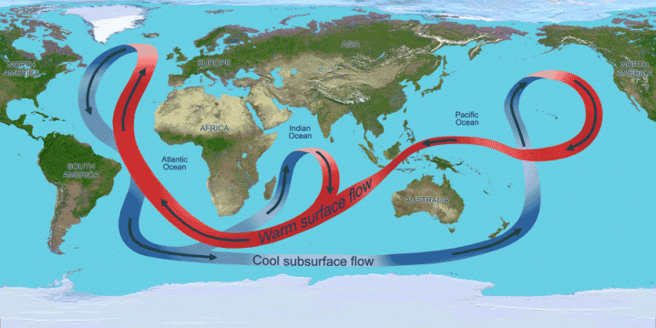
The ocean conveyor belt, also known as the global thermohaline circulation, represents a large-scale system of ocean currents responsible for the movement of vast quantities of upper-ocean water and the transfer of energy through deep-sea circulation. This process is primarily driven by the formation and subsequent sinking of cold, saline water into deeper ocean layers. Key controlling factors include salinity, temperature, and density.
In polar regions, cold and saline water becomes denser and sinks, flowing toward the equator and eventually dispersing throughout the deep basins of the Atlantic, Pacific, and Indian Oceans. Surface currents, in turn, transport warm water from the Indian and Pacific Oceans toward the North Atlantic, where it releases heat to cold air masses originating from Canada. As this surface water cools and increases in density, it sinks, initiating the deep ocean currents that play a crucial role in global heat regulation. Approximately one-third of the solar energy absorbed by the Earth is redistributed through this mechanism.
The North Atlantic is notably warmer than the North Pacific, resulting in higher rates of evaporation. Consequently, the remaining water becomes saltier and denser, sinks, and ultimately mixes with warmer waters in the Pacific Ocean, leading to a reduction in its density.
What drives the thermohaline circulation?
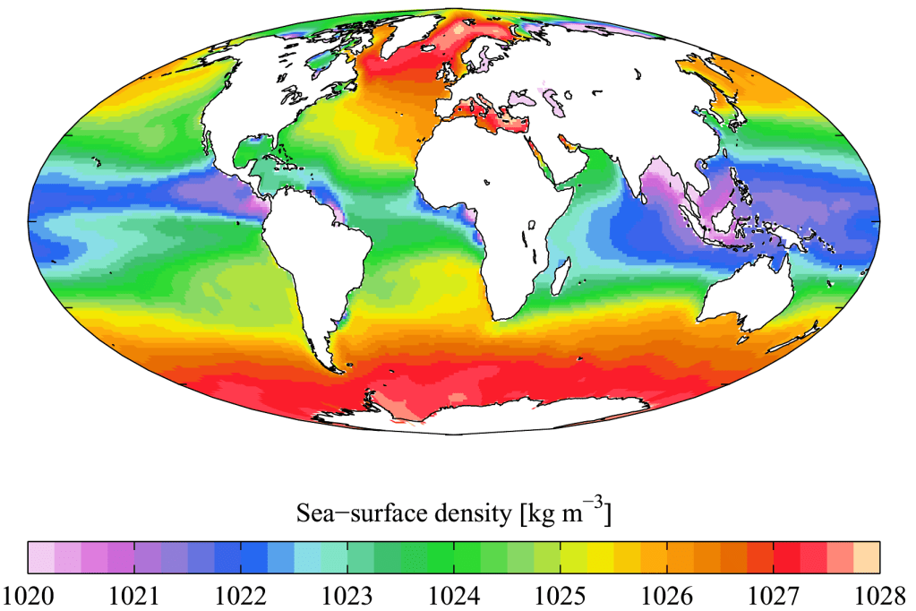
Ocean Salinity
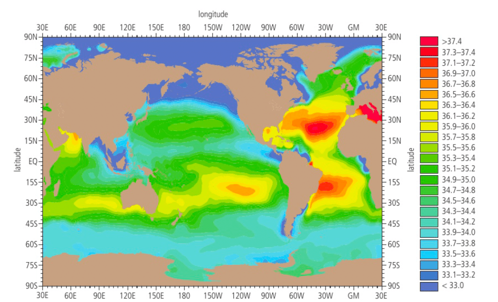
Ocean water exhibits spatial variability in salinity, with an average concentration of approximately 35 parts per thousand (ppt). Salinity levels are typically higher in warmer seas due to enhanced evaporation rates. In tropical regions, salinity decreases markedly with depth. Although the discharge from most rivers mixes rapidly with seawater and exerts minimal influence on overall salinity, large river systems such as the Amazon can lower salinity levels over distances exceeding one kilometre offshore. Processes of ice formation and melting also affect salinity: melting icebergs, composed of freshwater, decrease salinity, whereas the freezing of seawater temporarily increases it. In general, salinity tends to increase with depth, except in tropical waters where it declines. The predominant ions in seawater include sodium (30.2%) and chloride (54.3%), which together form sodium chloride, along with significant proportions of magnesium and sulfate ions.
Temperature
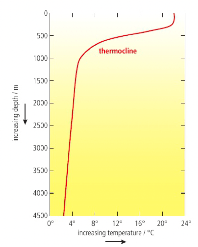
Ocean surface temperatures vary considerably across regions, while temperature fluctuations with depth are relatively small. In tropical and subtropical areas, surface temperatures often exceed 25°C due to high solar radiation. Between depths of approximately 300 and 1000 meters, temperature decreases rapidly to around 8–10°C, forming a pronounced thermocline. Below 1000 meters, the temperature stabilises at roughly 2°C. In mid-latitude zones (40–50° N and S), ocean temperatures also display seasonal variation, ranging from about 17°C in summer to 10°C in winter. Overall, temperature decreases progressively with depth, establishing distinct vertical thermal stratification.
Density
The density of seawater is determined by the combined effects of temperature, salinity, and pressure. Variations in these factors lead to the stratification of ocean water, as denser water masses tend to sink beneath less dense layers. Warmer water exhibits lower density, whereas higher salinity and pressure increase density. Consequently, cold, saline, deep waters are highly dense, while warm, less saline surface waters are comparatively buoyant. When water masses of differing densities converge, the denser water sinks beneath the lighter layer, a process that significantly influences deep ocean circulation and the global thermohaline system.
ENSO
Walker Circulation
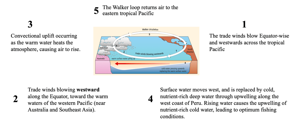
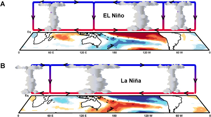
The El Niño Southern Oscillation (ENSO) is a naturally occurring climate phenomenon characterised by fluctuations in wind patterns and sea surface temperatures in the tropical Pacific Ocean. ENSO has two extreme phases: El Niño and La Niña, with neutral and transitional phases in between. This cycle occurs approximately every three to seven years, typically lasting around eighteen months. It is driven by changes in the Walker circulation, where trade winds either weaken or strengthen.
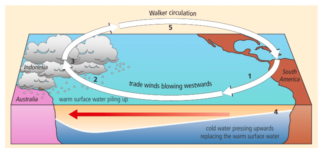
Walker circulation refers to the east-to-west movement of air across the tropical Pacific Ocean before returning eastward. The process involves:
- Trade winds blowing westward along the Equator, toward the warm waters of the western Pacific (near Australia and Southeast Asia).
- Convectional uplift occurring as the warm water heats the atmosphere, causing air to rise.
- Upwelling of cold, nutrient-rich water along the coast of Peru, replacing the surface water that moves westward. This upwelling creates ideal fishing conditions.
- A pressure difference between regions, leading to sea levels in Australasia being 50 cm higher than those near Peru, and sea temperatures being 8°C warmer in the western Pacific.

ENSO Phases: El Niño and La Niña
ENSO alters Walker circulation, disrupting normal climate patterns.
El Niño

Source: NOAA
During El Niño, the usual wind and ocean current patterns are reversed or weakened, leading to:
- Weaker or reversed trade winds, allowing warm water from the west to move eastward.
- A rise in sea level (up to 30 cm) along the coast of Peru.
- Warmer sea surface temperatures (by 6–8°C) in the eastern Pacific.
- Low pressure over the eastern Pacific (Peru and Ecuador), leading to heavy rainfall. Conversely, high pressure dominates the western Pacific, causing drought in Indonesia and Australia.
- Disruption of marine ecosystems, as the warm waters suppress upwelling, reducing phytoplankton and depleting fish stocks. This impacts the food chain, including fish-eating birds like those in the Galápagos Islands.
Source: Science Direct (S. Kaboth-Bahr, M. Mudelsee, 2022)
La Niña
La Niña is essentially a stronger-than-normal Walker circulation, bringing opposite effects to El Niño:
- Stronger trade winds, pushing warm water further westward.
- Sea levels rising up to 1 meter near Indonesia and the Philippines.
- Stronger upwelling off the coast of South America, leading to cooler ocean temperatures and extreme drought in Peru and northern Chile.
- Heavy rainfall in Southeast Asia due to intensified convection.
- Broader climate impacts, including increased rainfall in India and the Sahel (south of the Sahara), and wetter, colder conditions in western Canada.
Long-Term Stability of ENSO
Despite its periodic shifts, ENSO is part of a larger stable climate system in the Pacific. The alternation between El Niño and La Niña helps balance water availability in affected regions over time. For example, water shortages during La Niña are replenished during El Niño years, maintaining an overall equilibrium in local water cycles.
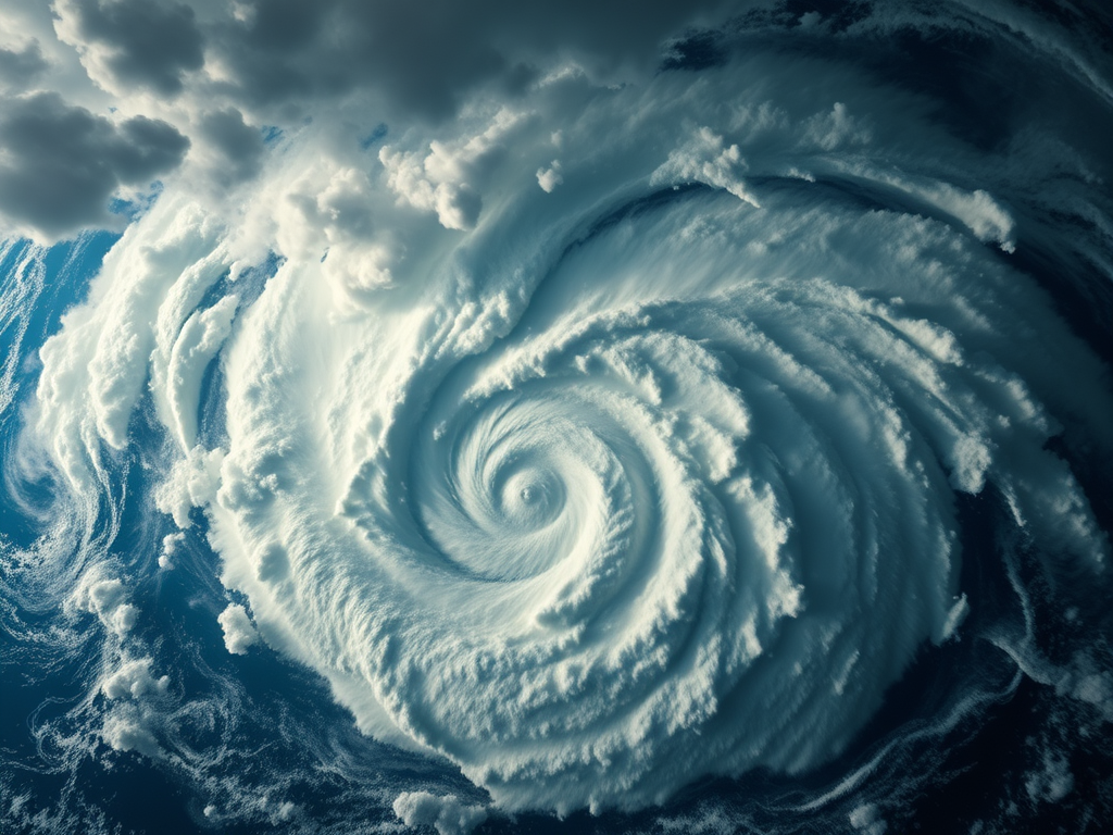
Tropical cyclones
In regions where surface water is warmed, large storm systems form, drawing heat from the ocean’s surface to fuel horizontal, rotating winds.
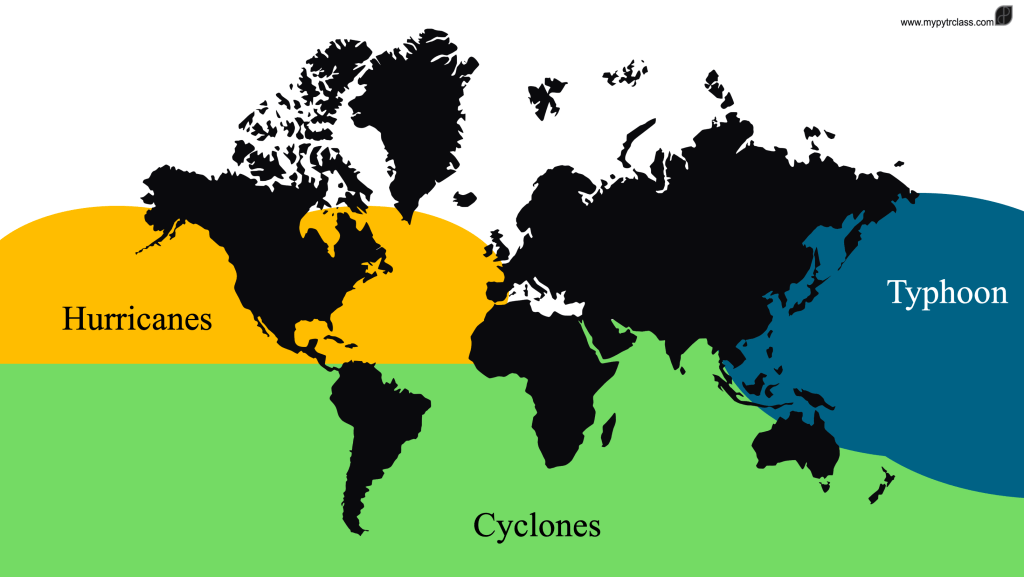
Hurricanes, typhoons, and cyclones are the same type of storm but are named differently based on their location of origin:
- Cyclones form over the South Pacific and Indian Oceans, impacting countries from Australia to Mozambique.
- Hurricanes develop over the North Atlantic, Central North Pacific, and Eastern North Pacific Oceans, often affecting the Caribbean and the eastern United States.
- Typhoons occur in the Northwest Pacific Ocean, frequently striking the Philippines and Japan.
These storms are all large tropical weather systems that rotate around a low-pressure centre, bringing intense rainfall and wind speeds exceeding 119 km/h. Their impacts can be severe, affecting marine fishing, agriculture, infrastructure, and human settlements, often leading to property damage and loss of life.
Cyclones vs. Tornadoes
The key difference lies in their scale:
- Tornadoes are much smaller, with diameters reaching hundreds of meters.
- Tropical cyclones are significantly larger, spanning hundreds of kilometers.
Learning Material
Subscribe to get access
Read more of this content when you subscribe today.
![ESS 8.1.3 [AHL] Biocapacity and Environmental Migration](https://mypytrclass.com/wp-content/uploads/2025/12/image-4.png?w=1024)


![ESS 8.3.4 [AHL] Photochemical Smogs and Tropospheric Ozone](https://mypytrclass.com/wp-content/uploads/2025/12/image-1.png?w=1024)